Saw a listing boasting “direct Gulf access” and wondered what that really means on Marco Island? You are not alone. The phrase sounds simple, but the details behind it shape how you actually use your boat and enjoy your home. In this guide, you will learn how access works here, what bridges, depths, tides, and speed zones can change your route, and how to verify it all before you buy. Let’s dive in.
Define direct Gulf access
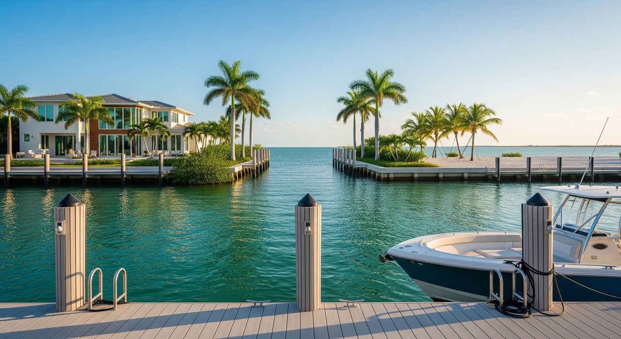
On Marco Island, “direct Gulf access” usually means you can navigate from a property’s dock or marina to the Gulf of Mexico without passing through any locks. Your route might be open water, or it could follow marked channels, passes, and residential canals.
That label does not promise a short run, deep water at low tide, or a bridge-free path. Some routes include one or more fixed or drawbridges, plus long no-wake zones. Marketing language can be loose, so you should confirm the specifics that matter for your boat and lifestyle.
Marco Island waterways overview
Marco Island sits along Florida’s southwest coast with a network of coastal passes, the Marco River system, and interior canals that connect to main channels. Tides, shoaling, posted markers, and seasonal sand movement influence how you travel.
Because depths and channels can change over time, it pays to check current charts and notices. Start with the official chart viewer from the NOAA Nautical Charts and review any updates in the U.S. Coast Guard Local Notice to Mariners.
What access looks like in practice
Homes or condos that front a main marked channel leading to a coastal pass are often described as direct access. The trip can be short and mostly open water, but you can still expect slow speeds within estuary areas and near docks.
Interior canal properties may still be direct access under the basic definition, yet your route could include narrow turns and multiple no-wake segments. That adds time and reduces average speed, which matters if you plan frequent offshore runs.
Speed zones you will encounter
Most residential canals and shorelines around docks are posted as no-wake. Approaches to beaches, marinas, and mangrove channels often carry reduced speed limits for safety and erosion control.
Main channels and passes typically allow higher speeds, but rules can change seasonally or temporarily. For the latest requirements, review the Florida Fish and Wildlife Conservation Commission boating regulations.
Bridges and clearance reality
Bridges can change whether “direct” works for your vessel. Fixed low-span bridges impose a vertical clearance limit that affects sailboats and center consoles with towers. Bascule or drawbridges can add wait times depending on opening schedules. Even low pedestrian or railroad bridges on secondary routes can be a factor.
To verify bridge information, cross-check multiple sources. Use NOAA charts for posted clearances, check the Local Notice to Mariners for any changes, and review Collier County’s official site for local projects or permits that could affect your route. When in doubt, plan a trial run to confirm clearances and timing in real conditions.
Depth, shoaling and tide timing
Channel depth at mean low water is the practical baseline for planning. Shoaling near passes and shallow flats can reduce real-world depth below what older surveys show.
Your safest approach is to pair official charts with local knowledge and tides. Review the NOAA chart viewer, then plan around predicted water levels using the NOAA tides and currents site for the Marco Island area. If your boat draws more water or carries a deep keel, test the route at low tide to see where it gets thin.
Everyday impact on boating and lifestyle
Transit time and fuel
Short, open routes save time and fuel, a priority for anglers and cruisers who go out often. Long interior canal transits with extended no-wake zones add minutes or more to every trip. Ask for typical transit time to the Gulf at idle and at cruising speeds, and verify during a showing.
Vessel choice and maintenance
Shallow approaches favor flats boats and bay boats. Deep V offshore boats or sailboats with tall masts may need tide planning or alternative storage. Properties closer to open water can see more wake and wave action at the dock, which may require heavier-duty lifts, pilings, and seawalls.
Insurance, flood risk and hurricane planning
Waterfront locations near open water often sit in higher FEMA flood zones, which can affect flood and wind insurance costs. Verify a property’s designation using the FEMA Flood Map Service Center. For storms, direct access can help you relocate a vessel quickly, yet exposed docks may need more robust mitigation.
Noise, traffic and lifestyle tradeoffs
Living near a main channel or popular pass can bring boat traffic and sound, especially during peak season and events. Many boaters prefer the convenience of a quick Gulf run and proximity to marinas, fuel, and service. Decide which balance suits how you plan to use your boat and home.
Resale and valuation
Short, unobstructed routes often command a premium among offshore boaters. Value still depends on neighborhood demand, dock and lift capacity, recent dredging, and how well the property fits the vessels most buyers use here.
A buyer’s due diligence checklist
Use this list to verify that “direct Gulf access” matches your needs.
Ask the seller or listing agent
- Provide a simple map or written route description from the dock to the Gulf, including channel names and markers.
- Confirm the measured vertical clearance of every bridge on the route and if any drawbridge openings are needed.
- Share typical transit times to the Gulf and to the nearest fuel and repair facilities at idle and at cruising speed.
- Provide historical depth or dredging information for the immediate canal and the marked route you will run.
- Disclose any HOA, deed, or county restrictions on dock size, lifts, pilings, or mooring.
- Offer records of prior storm claims, seawall or bulkhead repairs, and maintenance schedules.
Verify independently
- Check the NOAA Nautical Charts viewer for channel alignment, markers, and charted depths.
- Scan the U.S. Coast Guard Local Notice to Mariners for temporary hazards, closures, or changes to aids to navigation.
- Look for recent dredging or shoaling advisories with the U.S. Army Corps of Engineers Jacksonville District and browse Collier County for local coastal maintenance or permitting records.
- Confirm flood zone and base flood elevation in the FEMA Flood Map Service Center.
- Check tides and currents for your planned usage windows at NOAA Tides and Currents.
Do an on-the-water test
- Run the route from the property at low tide and at a time you would normally go out. Watch depth, current, bridge clearance, and traffic.
- Measure your boat’s air draft if you have a mast, hardtop, radar array, or tower, and compare it to posted clearances.
- Speak with nearby marina teams and waterfront neighbors about shoaling patterns, dredging history, and seasonal congestion.
How The Sprigg Group helps
Waterfront decisions on Marco Island are both technical and personal. You want the right home or condo and a route that fits your boat and your routine. Based at Rose Marina, our team pairs residential waterfront brokerage with yacht and boat-slip expertise, so you get precise guidance on docks, lifts, routes, and marina logistics.
Here is what that means for you:
- Local route insight. We study tides, speed zones, and bridge realities so your access is matched to your vessel.
- Curated inventory. We align homes, condos, and premium slips with the boating profiles we see every day at the marina.
- Concierge management. From on-water trials to coordinating marine contractors, we manage details for local and out-of-state clients alike.
Ready to find the right waterfront fit? Connect with The Sprigg Group for tailored guidance and curated options. Create Your Paradise — Start Your Waterfront Search.
FAQs
What does “direct Gulf access” mean on Marco Island?
- It means a navigable route from a dock to the Gulf without locks, but it does not guarantee short distance, deep water at all tides, or a bridge-free path.
Do bridges still count with direct access listings?
- Yes, a route with fixed or drawbridges can still be marketed as direct access, so you should verify bridge clearances and opening schedules for your boat.
How do no-wake zones affect my trip time?
- Most residential canals and near-shore areas are no-wake, which can significantly increase transit time until you reach main channels with higher speed limits.
How can I check depth and bridge clearances before buying?
- Review the NOAA Nautical Charts viewer and the Local Notice to Mariners, and plan a trial run at low tide to confirm real conditions.
Will direct Gulf access change my insurance costs?
- Properties near open water can fall in higher FEMA flood zones, so confirm your exact zone in the FEMA Flood Map Service Center and discuss coverage with your insurer.
What should sailboat owners focus on when shopping?
- Prioritize fixed bridge clearances, channel depth at mean low water, and recent shoaling history, then test the route at low tide to ensure adequate depth and air draft.